‘Ulap’ is LOVE
‘Difficult roads often lead to beautiful destinations.’
From Pinatubo to Ulap

I originally intended to organize a Mount Pinatubo day hike for my next climb together with my colleagues, but the high cost of registration and other fees via the Sta. Juliana, Capas trail which I deemed unreasonable made me decide to cancel it. My eagerness to finally conquer this mountain which is situated between the boundaries of Tarlac, Pampanga and Zambales, was not enough to proceed with my plan since it will be hard for the participants of my event to shoulder a considerable sum of money with Christmas season just looming around the corner. Finding an alternative mountain to climb was easy. I didn’t have any other option in mind but Mount Ulap which was located in Itogon, Benguet. I have been to Ulap before, five months earlier to be exact, and I knew exactly that Ulap was an easy climb and its beauty was incomparable and distinct, even from other Cordillera mountains.

Planning a Mount Ulap day hike was also easy considering that information is available all over the net. Setting the budget and encouraging participants was also an easy task either. Although I encountered some problems regarding our mode of transportation to Itogon and how to get there, still, it was settled at the last moment. Even before the climb, I was quite confident that my participants would not regret joining me on this climb. All was perfectly settled and I was ecstatic on our journey come December 10. I was just so preoccupied and happy that day that it never occurred to me that an unexpected flaw can happen.
= = = = = = =
‘Find a beautiful place and get lost.’
The Unreliable GPS

We departed from Tarlac City at around four in the morning en route to Itogon. I have been to Mount Ulap before but I really had no idea how to get to Ampucao barangay hall, where the jump-off point is located. I turned to Google maps and started using GPS to navigate our way to barangay Ampucao in Itogon. The early morning travel went smoothly. We had a stopover in La Union to eat breakfast and then had another short stopover at the Lion’s Head along Kennon Road. After some photo shoot we continued our travel that led us to Baguio City. The GPS proved to be helpful until we reached Loakan Road and passed the PMA (Philippine Military Academy) gate. Then, following the navigational system instruction, we entered Balatoc Road instead of the Philex Road, which we learned later was the wrong route to Barangay Ampucao.

After less than an hour traversing Balatoc Road we came to a police checkpoint. When the police officer asked us where we were heading that was the only time we learned that we were on the wrong way. We then realized that we needed to go back and take the Philex Road to get to our destination. Due to my frustration, I immediately turned off the GPS and decided to ask the locals living in the area. We lost more than an hour for that unexpected glitch but I admit there was some thrill and adventure about what transpired. We simply made funny remarks about what happened. We finally reached barangay Ampucao at 8 in the morning. We proceeded to the barangay hall compound which serves as the jump-off point and registration site. I immediately went to the front of the barangay hall to register and pay the necessary fees, including our guides for the trek.


It was a Sunday when I first went there and I don’t remember seeing a lot of hikers in the barangay hall compound, unlike that particular Saturday. Considering it was already late morning, the groups of people scattered around the area surprised me. Until that moment, I had no idea how popular Ulap had become to receive such a huge crowd of hikers. After all was prepared, we did some photo shoot in front of the barangay hall. Then, we met our two guides and listened to them as they did some orientation. Shortly after the orientation and simple introduction, we started the trek.


Since we got lost along the way to Ampucao it was expected that we started the trek late, but I was still optimistic that we are still beyond our itinerary. Since most of my companions are novice hikers I decided to do a back trail instead of the usual Ulap traverse that culminate in Sta. Fe. During my first time in Ulap, I found the descent to Sta. Fe challenging and exhausting. I deduce that first timers will find the trail too hard and technical. Everyone agreed on a back trail as I explained the situation to them.
= = = = = = =
‘Life was meant for good friends and great adventures.’
The new Ulap

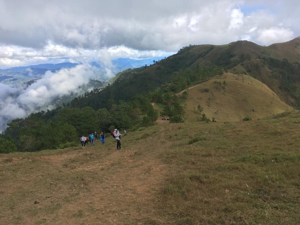
Our initial ascent on a concrete path led us to the welcome marker of the Ulap's eco-trail. After our photo shoot, we continued our trek. It was then that I immediately saw the first obvious changes in the mountain. There was a makeshift arc and signage at the view point area at the start of the eco-trail. You can take picture there and we saw two people manning the area and a donation box at one area for those willing to donate some money. We didn’t bother to stop and take pictures when we passed the area because there was no clearing anyway. We proceeded with the trek and then reached the still-present little nipa hut. Once again, we made a stop there for some photo shoot. The view from that location was breathtaking. Everyone was in awe with the scenic Cordillera mountains which served as the back drop for our photo shoot. The never ending photo shoot went on for the duration of the trek as we constantly made stop overs. I was glad that everyone seemed delighted and were enjoying the sights as they were busy savoring the moment and have their individual photo taken.


The constant ascent was a concern for some in the group but seeing and meeting other hikers along the trail somehow ease their doubt and made them comfortable. Then, we finally reached the first peak, which is Ambanaw Paway. Again, I noticed something different that was not there before. There is a marker now in the area indicating the name of the peak, its height and distance from the jump-off point. Just below the peak is the Campsite 1, which was not there before. The lone campsite used to be located at the foot of the third peak or Ulap’s summit.


From where we were standing, we saw the hill adjacent to the first peak. The hill was laden with piled stones at the top and I was able to climb it during my first time there. This time though, my companions were not keen on going to the hill because you would have to make a steep descent from the first peak and then make another steep ascent to reach the top of the hill. We instead proceeded to the second peak, making a descent which proved to be challenging for all of us. Our guides assisted the group, especially the ladies, in the steep trail. I noticed the deteriorating part of that trail and I deduced that it may be attributed to the influx of hikers to the mountain. It was evident that a lot of people are going to Ulap for the same reasons we went there.


The trek along the ridge leading to the second peak or the Gungal Rock went on with constant stop overs to rest. That time, the mountain became foggy and I began to fear that there will be no clearing at the Gungal Rock. What also concerned me was how long the queue of people who were waiting for their turn to have their picture taken in the most famous rock of Ulap. We know that there were groups ahead of us, so we expected that it would take long before can have our turn in the Gungal Rock.


It took some time before we finally reached the second peak. We all converged near the peak to take a short respite before proceeding to the Gungal Rock. From where we were we can see the crowd of people near the Gungal Rock. Our guides went there first to fall in line for us. Then after a few minutes, we went ahead and made a short stop at the second peak marker for some group photos. We arrived at the second peak area a few minutes later. It was lunch time during that time so we decided to take our lunch first while waiting for our turn on the Gungal Rock.


While having our lunch, I doubted the possibility of a good view at the Gungal Rock. Like my previous visit there, the fog was again engulfing the whole area. I was hopeful, but until the end, the weather did not grant my fervent wish. After our lunch, we went straight to the Gungal Rock. We hastily went to have our turn on the rock but there were still people in line. Most of the people in the group were afraid to step or go near the rock since it seems scary because it has a steep part and below it is a deep ravine. The weather began to get unpredictable and there was a slight drizzle. We did not wait for our turn in the Gungal Rock as we did our photo shoot just beside it. After that we all decided to make our way back to the jump-off point.
= = = = = = =
‘Mostly, we don’t remember the days, we remember the moments.’
Back trail and short cut

We made our way down as the fogs continue to engulf the whole mountain. Just after beginning our trek back to the jump-off point, one person in the group experienced muscle cramps, so we had to make a stop to attend to her. We proceeded with the trek and made some constant stops to rest as our companion continued to experience muscle cramps. Together with one of our guides, we trail behind the group. Even though I feared about the possibility of a sudden downpour, the three of us made our way down slowly and cautiously, not hurrying at all.


Ulap’s back trail is my first and is obviously shorter and easier than the traverse. During our way back, we passed a different route, which seemed easier and a shorter path compared to our previous route that was much more challenging. The trail with the easier route was a breather since it was easier and much safer to us. We continued with the trek in moderate pace until finally reuniting with the rest of the group along the Ulap welcome marker. After finding a place to take a bath and change clothes, we all boarded our van and leave Ampucao.


Shortly after leaving barangay Ampucao, rain began to pour. I just sighed in relief that we made it down before it happened. We were suppose to make a side trip to Baguio City, but since one in the group needed to get back home early, we decided to skip the plan and head home instead. There was a downpour in some parts of Kennon Road as we made our way to Tarlac. We made a short stop again at the Lion’s Head to buy some pasalubong. Then we proceeded with the journey, making another stopover in Pangasinan to have dinner. We reached Tarlac City earlier than expected. The journey ended well and I was relieved that the second climb I organized was a success.
= = = = = = =
‘The future depends on what you do today.’
Loving and saving Mount Ulap

For the second time, Ulap did not disappoint me. Although we only did a back trail, I was still able to experience something new with this famed Cordillera mountain. The newly installed markers, the ever amazing views, the flock of hikers you meet along the trail are more than enough to fall in love with Ulap all over again. The lack of a clearing at the Gungal rock was disappointing, but it just gave me reason to come back.

Another worthy observation is the flock of hikers in Ulap. On our way down we met a lot of hikers of all ages on their way to the summit, with some obviously staying there overnight. I’m afraid that this will soon lead to the exploitation and degradation of Ulap’s beauty and habitat. There are some parts of the trail which seemed to be deteriorating. The presence of some irresponsible hikers also poses a threat to Ulap. I even saw one hiker that simply threw a piece of trash along the trail. Was he unaware of the LNT (leave no trace) principle? It is disheartening to know that there are some who climb mountains without proper training and knowledge about basic mountaineering principles. By the looks of them, I guess some of those I saw along the trail are novice hikers. I have no idea what is their reason in going to Ulap, but I hope it is a significant one.


Having experienced an Ulap traverse and back trail, both on day hikes, they didn’t have any difference. Ulap never failed to fascinate me with its beauty and charm. I would love to return there for a third time or even a fourth time. If ever, I may consider a reverse traverse, or to make it more exciting, an overnight hike. Ulap’s charm is hard to ignore or even forget. The trail from Ampucao to Sta. Fe was easy to moderate and manageable even to first time climbers. I will content myself in believing that the reason why people flock to Ulap is because of its natural beauty. I just hope that any attempt to improve and promote this Cordilleran mountain will end up being beneficial to all stakeholders, especially to the environment. Proper management of the mountain is also important. This is crucial for the maintenance and rehabilitation of the eco-trail. To those who have been to Ulap and those who plan to go there someday, let us do our share to save this mountain from possible deterioration or destruction. Let us treat the mountain and its environment with much love so that we can see more of Ulap’s beauty in the future.
Itinerary
03:00 AM Assembly
04:00 AM ETD Tarlac City
05:30 AM Breakfast
08:00 AM ETA Brgy. Ampucao/Register and secure guides
08:45 AM Start trek
11:00 AM Peak 1 - Ambanaw Paway
12:30 AM Peak 2 - Gungal Rock/Lunch
01:00 PM Start descend back to Brgy. Ampucao/Lunch
03:30 PM ETA jump-off point/Wash up
04:30 PM ETD Brgy Ampucao to Tarlac City
05:30 PM Lion’s Head/Pasalubong shopping
07:00 PM Dinner
08:30 PM ETA Tarlac City
CONTACT INFORMATION:
Barangay Ampucao
Office of the Punong Barangay
E-mail address: ampucaolgu@yahoo.com
Facebook page: https://www.facebook.com/mtulap.ecotrail
Contact number: 0921-523-6630
*Starting February 4, 2017 all groups (organized or not) who will trek/hike/camp at Mt. Ulap Eco-trail are required to make prior reservation and shall be limited to a maximum of twenty (20) individuals only. The latest advisory from the Office of the Barangay Council of barangay Ampucao also state that hikers at the Eco-trail shall be limited to: 500 people during weekends and holidays, and 150 people during weekdays.


Comments
Post a Comment