On The Top of 'Ulap'
‘Wherever you go, go
with all your heart.’
On The Road

I almost backed out of our Mount Ulap hike. I had plenty of reasons to do so, although none of them
made sense. Maybe I was just making excuses and one main reason was the long
travel to the Cordillera region. I had enough of our previous trips to Banaue
in Ifugao and Kabayan in Benguet which proved to be taxing. I also find the journey
amidst zigzag roads spine-chilling. But then, I kept reminding myself that I’ve
already made the commitment to join the trip and it was very unprofessional to
back out with no good reason at all. In the end, my curiosity about Ulap’s famed
Gungal Rock finally convinced me to do the climb.

Barely two weeks
after conquering Mount Pulag, I again found myself traveling to Benguet to
conquer another famous Cordilleran mountain. The journey started as early as
Saturday evening since it was a long way to Itogon. My usual routine whenever our group had a climb up north is to wait for them at Mabalacat, Pampanga. This
time around, I have a companion, Rein, who was a fellow Kapampangan and happens
to be living in Mabalacat. The van and the group arrived in Mabalacat at 1 am. Rein
and I immediately got inside our respective van. Unfortunately, we were not in
the same van. I occupied the remaining seat at the back of the van. It’s not a
comfortable seat to say the least. As I settled in my seat, I couldn’t help but
shake my head as I knew how the journey would go.

From Dau in
Mabalacat we made our way to Mac Arthur Highway. The driver took an unusual
route which surprised me. We usually took the North Luzon Expressway (NLEX) or
Subic Clark Tarlac Expressway (SCTEX) en route to the north. This time though, we traversed the highway all the way to Tarlac. After more than one hour of
traversing the highway, we made a stopover at a convenience store in Capas, Tarlac.
We took the opportunity to buy some supplies while our driver took time to rest.
The journey resumed after a few minutes.

We made another
stopover in a gasoline station in La Union before entering Kennon Road. Then,
it was a continuous journey all the way to Itogon until finally reaching
Ampucao. We made a detour and headed to the barangay hall. After parking our
van in the designated area, we made the preparations and sorted our things and
changed into our hiking attire. We left some personal belongings inside the
van. This is a traverse climb and the van will be waiting for us at Santa Fe where
we would be making our exit.
~~~~~~~~
‘Life is either a
daring adventure or nothing at all.’
The Three Peaks

Alvin, the coordinator of this event, made the mandatory registration and secured our guides. Since we were still waiting for one participant coming from Baguio City, we decided to eat our breakfast. I simply bought hot chocolate from one of the stores there. While taking my breakfast, I had time to scan the jump-off point. The Ampucao barangay hall was spacious. Situated at the corner is the barangay hall which is a two storey building. At the front of the building was the registration area. There in the second floor were the bathrooms. The parking area just beside the barangay hall was actually an indoor basketball court which was full with vehicles from others hikers.


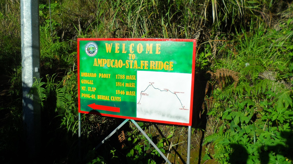
After everyone was ready, we started gathering around in front of the barangay hall. Our guides headed the orientation before commencing the trek. They explained what we needed to know about Ulap’s Eco-Trail including the three peaks and the usual reminders to hikers. It was 6:30 in the morning when we started the trek. From the jump-off point we walked back to the highway. We made a left turn after reaching the highway and crossed it and then ascended a narrow concrete path. After 30 minutes of the steep ascent we reached the signboard welcoming hikers to the mountain with an illustrated trail map of the Ampucao and Santa Fe ridge. We made a stop there to rest and take pictures.


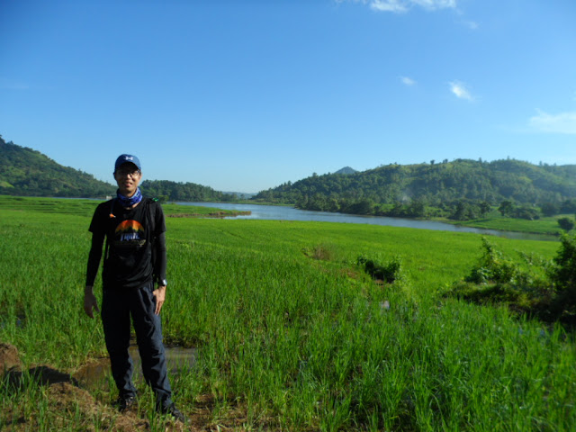
We proceeded with the trek and after a few meters reached a resting area with a small hut. There was a good view from there so we made another stop and took pictures. After a few minutes we proceeded with the trek. The steep assault was somehow manageable. Our guides proved to be reliable as they stayed behind us as we went along. The initial part of the trail was the pine forest with the scenic views of the surrounding mountains. The temperature was cold because of our high altitude although it was not evident due to the presence of the moderate heat of the sun.


We made countless stopovers along the trail. We couldn’t help it but stopped every now and then to take pictures as the views of mist-covered Cordillera Mountains were so enchanting and surreal. Our guides just sat there while patiently waiting for us although at times couldn’t resist reminding us that we must proceed with the trek. We reached Peak 1 or what they called Ambanao Paoay after more than two hours. The vast ridge of grassland slopes of Ambanao Paoay was just amazing. The grassland is known for grazing cows, no wonder we saw animal manure along the trail and I almost stepped into one. We even saw a cow along the trail and had to pass by its side carefully taking extra precaution in case the animal got intimidated and attacked us.


The grassland slopes of Ambanao Paoay proved to be a hit for most of us. Others chose to spend time taking photos at one slope of the hills while we decided to make the descent and then scale to the summit. The summit stood high with its lone tree at the top and with the interesting pile of rocks that were scattered everywhere. Sadly there was no good view on top because of the mist covering the summit.


It was not long before we decided to make a descent to the summit and continue the trek to Peak 2. I began to be impatient as we walked along the seemingly endless trail of grassland. We were all anticipating reaching Peak 2 where the famous Gungal Rock could be found. My curiosity about the rock was killing me that I hastened my pace and went ahead of the group as they seemed to be enjoying their time taking photos. Our guide was leading so I decided to catch up with her leaving the group trailing behind us. We passed through several slopes of grassland before finally setting our sight on the rock formations of Peak 2.


Peak 2 or the Gungal Rock was crowded when we arrived. There were hikers that were already taking pictures in the rock and there was a long line of people behind them. Our guides made the arrangement so that our group could have the chance at the rock. Hikers waiting for their turn were scattered along the area, some taking refuge to shaded parts since it was almost noon and the heat was intense.


While waiting for
our turn, we decided to take our lunch. We found a place a few meters opposite
the Gungal Rock. We braved the heat of the sun and ate our lunch. The cold
breeze in the mountains somehow made us endure the intense heat. The heat was
bearable as the expansive view of the surrounding mountains was rewarding
enough. An influx of hikers continued to arrive at Peak 2 that it became
increasingly crowded.


After consuming our food, we headed to the rock to wait for our turn. It was then that I began marveling at the rock formation. It was disheartening though to see that the surface of the rock was vandalized. The Star of David inside a circle was inscribed in the rock. Our guide had no idea who did the act and told us it has been there for a long time. The purpose of the symbol has been lost but through time, it became a part of the identity of the rock itself.


Upon a closer look at the rock, I realized that stepping on it was not as scary as I thought. The angle of the rock was not that inclined, contrary to what it looks like in photos. Stepping on the slab of rock was safe as the guides were there, providing assistance. They were taking extra precautions though, as they didn’t allow hikers to sit at the tip of the rock. It was reasonable considering that below it was a deep ravine and carelessness would be fatal.


When it was finally our turn, we hurriedly lined up to have our pictures taken. We only had 3 poses to make before our turn was up and gave the next person in line their chance. I carefully made my way to center of the rock and did random poses. It was unfortunate though that the clouds were engulfing Peak 2 during that time, blocking the breathtaking view of the surrounding mountains. Nevertheless, I was still proud of having the opportunity to experience the famed rock.

After everyone had their turn at the Gungal rock, we decided to continue the trek, this time we were headed to the last peak, Peak 3 or the highest point of Mount Ulap. The trek along the slopes of grasslands continued. We even encountered parts in the trail which were blocked by fences and we had to cross over them. We arrived at the foot of the summit with some people in the group ahead of us. As we were already exhausted, we thought of not scaling to the summit anymore and instead headed directly to the campsite just below it.

After some hesitation, some of us decided to head to the summit while most in the group decided to head straight to the campsite. We found out later that there was nothing to see at the summit as it was covered in clouds. There was a flag erected at one spot where I decided to have my picture taken. During that time, I had a hunch that it was going to rain. We did not stay long at the summit and immediately made our way down to the campsite.


The descent from the summit to campsite was steep. On our way down we saw some members of our group already there in the campsite, lying on their backs in the grass and some taking a nap. After much cautious effort descending we were reunited with the rest in the group. We didn’t linger long enough at the campsite as there was nothing to do there anyway.
~~~~~~~~
‘Adventure is
worthwhile.’
Setbacks

After a short respite, I told Rein to make our descent as I was in a hurry, keeping in mind the possibility of a downpour. Others were already ahead of us together with one of our guides. We decided to follow them and took the short cut on our way down to Santa Fe. It was initially a steep descent as we moved away from the campsite but afterwards, it was a never ending descent of 80-85 degree slope of pine forest. It was the most challenging part of the trail. There were wooden bars as support along the ladder-like-trail which was a big help. The pine forested terrain was also a relief for the reason that it gave us protection from the sun.

I was leading with Rein trailing behind. I lost sight of the group, so I just continued walking and tried following the trail. There came two instances though that I lost track of the trail and didn’t know which way to go. I took the risk and relied on my gut feel. I continue walking until ultimately saw the trail. I did my descent slowly with constant rest. I passed the Pong-ol burial caves but I was too preoccupied to notice them. Then, I began to feel a sudden jolt of pain in my right knee. I’ve experienced this in some of my climbs before so I didn’t worry much; I just endured it and kept going on.


After an hour descending the steep forest, we reached a row of houses. I initially thought we were finally at the exit point. We made a stop there. While taking a rest I looked around and bought some souvenir items from one the stores there. I also rewarded myself with a refreshing melon shake. We were surprised to learn that it was still a 30 minutes journey to the Santa Fe exit point. Thus, after regaining enough energy, we proceeded with the final part of the descent.

I’ve lost count of how many sari-sari stores, row of houses, and hanging bridges we passed. The steep trail down to Santa Fe continued until we reached a paved footpath. The journey from there was easy. We hurried our steps until we reached the highway where our van was waiting alongside the road.

As always, taking a bath after a whole day of trekking was the next thing I did. We found two shower rooms just along the highway in Santa Fe. Rein and I immediately fell in line as there were already hikers there waiting for their turns. As we sat there waiting, the rain suddenly poured. I immediately thought of our companions left behind. Maybe they were still on their way down during that time. I felt worried for them since I know how hard it was to trek in this condition.

Rein took his turn first in the bathroom. The rain was still taking its toll until my turn came. I was shaking when I took my bath. The weather was as cold as the water in the shower. I just had a quick shower before finally changing into new clothes. The rain reduced to a drizzle after an hour. I boarded our van and stayed there to stay warm while waiting for the others.

As I took comfort inside our van the rest of the group arrived one after another, drenched in rain water. I just took my time inside the van until everyone was done and all set to go. We then headed to Baguio City. It was also raining in the city of Pines when we arrive there. We headed to a famous restaurant in the city proper and there we had our dinner.

It was 8 pm when we left Baguio and headed back to Manila. We again traversed the Mac Arthur Highway all the way to Tarlac City. They dropped me near our place, and I was grateful as I made it home early. I had a lot of catching up to do with sleep.
~~~~~~~~
‘The world is
endlessly fascinating to those who take the time to look.’
All About Cordillera

Although Ulap is
known for its iconic Gungal Rock, there are actually a lot of reasons why you
should visit this mountain. Our trek took longer than usual because of the constant
stop overs. There were many scenic spots along the trail and you can hardly
resist the opportunity to stop and take pictures every now and then. Gungal Rock was the highlight of the trek, although there were other worthy attractions
- from the grassland slopes of Ambanao Paoay to the pine forest, burial caves,
and hanging bridges of Santa Fe. It’s just a matter of how you look at things, with
Gungal Rock being crowded and all; your options are actually limitless in this
mountain. Just have the leisure to roam around and you’ll appreciate every part
of this eco-trail.

To say that I did
enjoy my Mount Ulap hike is an understatement. My journey to this mountain was
one of my best and most unforgettable climbs ever. Ulap’s beauty lies in the breathtaking
scenic landscapes along its trail. Added to its charm was the infinite presence
of clouds that somehow gave the mountain its moniker. Having been to Batad in
Banaue, Ifugao and Pulag in Kabayan, Benguet, made me wonder on what was so unique
about Cordillera mountains that always fascinates me. I guess it had something
to do with their topography and high elevation that sets them apart from other
mountains I had visited; or perhaps, it’s all about the locals and their
culture that made my every journey to this region worthwhile and enlightening.
CONTACT INFORMATION:
Barangay Ampucao
Office of the Punong Barangay
E-mail address: ampucaolgu@yahoo.com
Facebook page: https://www.facebook.com/mtulap.ecotrail
Contact number: 0921-523-6630
*Starting February 4, 2017 all groups (organized or not) who will trek/hike/camp at Mt. Ulap Eco-trail are required to make prior reservation and shall be limited to a maximum of twenty (20) individuals only. The latest advisory from the Office of the Barangay Council of barangay Ampucao also state that hikers at the Eco-trail shall be limited to: 500 people during weekends and holidays, and 150 people during weekdays.


Comments
Post a Comment